Research Projects
My research examines questions of racial and socioeconomic inequality related to neighborhood conditions and urban policy. Spanning the social sciences of urban economics, sociology and geography, as well as the topical domains of urban planning & policy, housing, education, and public health, the unifying framework of my research is a focus on formal analyses of spatially-explicit relationships, and the connection between social theory and spatial methods.
Urban Analysis and Spatial Science
Theory, Methods, and Code for Applied Research in Spatial Social Science. Spanning the fields of urban economics, analytical sociology, and quantitative geography, this volume provides an introduction to core concepts and quantitative research methods in urban analytics and the spatial analysis of cities using the Python programming language. It blends classical theory with modern coding examples providing a foundation for contemporary social science and policy research using formal spatial methods.
MoreAn Open-Source Ecosystem for Spatial and Urban Data Science
This project aims to establish the long term viability and dynamism of an open source ecosystem for spatial data science with PySAL at the core. Through bidirectional channels of integration PySAL both benefits from and contributes to the broader ecosystem, and through the ecosystem, PySAL is able to reach a broader audience of users and developers. Moreover, by strengthening the channels of integration with the ecosystem, we are able to leverage the broader community to help address the challenges of academic software development
Moregeosnap4ed: Neighborhood Analysis in Education Research
geosnap4ed is designed to develop new methods for neighborhood analysis and build analytical capacity among education researchers and practitioners. The project focuses on enhancing the geosnap software package to increase field understanding of spatial analysis and neighborhood dynamics as inputs toward identifying how best to support schools serving Black, Latino, and low-income students.
Addressing Opioid Overdose Disparities in Inland Southern California: Ethnography Meets Advanced Spatial Analytics
Drawing from spatial data science, anthropology and public health, this project seeks new insight into the spatial contexts associated with opioid overdoses in Riverside County. By combining qualitative and quantitative methods in partnership with local public health agencies and emergency services, the goal of this project is to identify the best ways to help mitigate overdose harm and disparities by synthesizing spatial econometrics, ethnographic interviews, and spatial optimization modeling
MoreNeighborhood Influences Over the Life Course: Families, Twins, and Spatial Contexts
The Colorado Adoption and Twin Study of Lifespan behavioral development (CATSLife) began over 30 years ago, using longitudinal data from twins, siblings, and families to study behavioral and cognitive development over the life course. In its new iteration, CATSLife2 also includes a major focus on the sociospatial contexts, using high-resolution data to examine the dynamics of neighborhood influences and individual outcomes change over time.
MoreScalable Segregation Analytics
This project develops new methods for the treatment of uncertainty in the American Community Survey data, a new framework for statistical inference in the space-time analysis of segregation, and scalable algorithms for regionalization and spatially explicit aggregation of areal units. The project will develop a new scalable spatio-temporal data management layer to support the application of these three sets of analytics to large datasets. Major outputs include the PySAL segregation package, and its associated measures of statistical inference and decomposition
Modeling Neighborhood Space-Time Dynamics
This project will produce new methods for neighborhood identification and analysis that draw on recent developments in geographic information science and spatial statistics. These new methods will enhance the urban social science toolkit enabling researchers to carry out empirical work that can be replicated, thereby moving urban policy research onto stronger analytic foundations. Major outputs include the geosnap software package, and its associated methods for modeling and simulating neighborhood change.
Spatial Inequality Dynamics
This research project develops new analytical methods for the study of spatial dynamics of income inequality; specifically, new approaches measure changes in the distributional characteristics of those dynamics that incorporate their spatial dependence and heterogeneity. The new methods include both global measures that report summary properties of the spatial dynamics as well as local indicators that can be used to identify hot-spots of locations that are important drivers of the overall dynamics or are outliers from the global trends. Major outputs include enhancements to the PySAL giddy and geosnap software packages.
Modeling The Geography of Opportunity for Fair Housing Policy
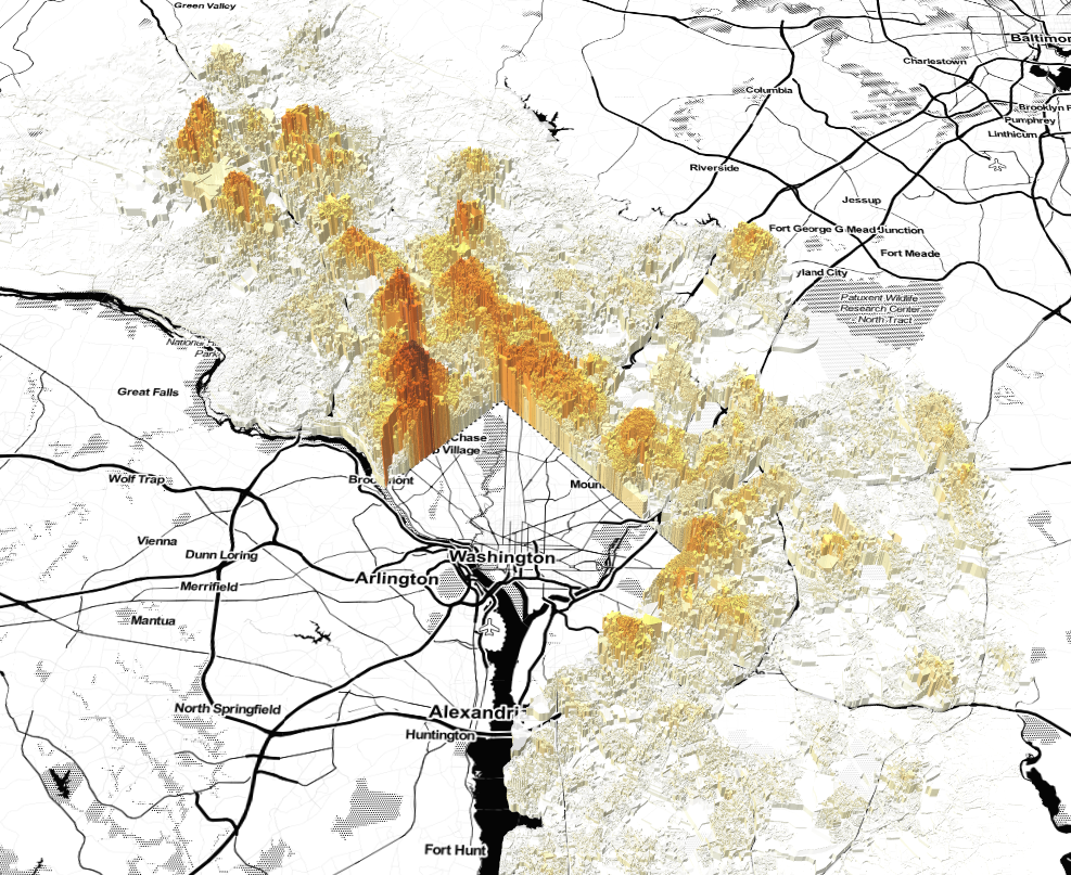
The geography of opportunity is a well-known phrase used to describe the ways that neighborhoods shape important outcomes over the life course. My work on modeling the geography of opportunity formed the foundation of HUD’s formal evaluation of the Baltimore Housing Mobility Program. It also served as the basis of large portions of the Baltimore Regional Plan for Sustainable Development while I was a research assistant at NCSG, and Opportunity360 when I was a postdoctoral fellow at Enterprise Community Partners Inc.
MoreEmployment Centers & Accessibility: Polycentric Agglomeration as an Economic Development Strategy
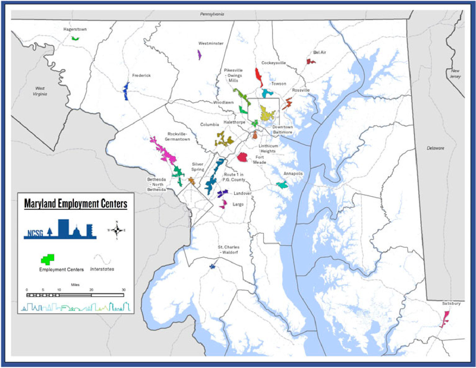
This project focused on identifying (ultimately 23) economic centers in the Baltimore-Washington region, then examining these centers first in their role as clusters of economic activity, then in their role as nodes in the state’s transportation system. At NCSG, we identified the commute sheds of each center for multiple modes of travel and travel times, and examined jobs–housing balance within these various commute sheds, finding that Maryland’s economic centers not only promote agglomerative economies and thus facilitate economic growth; they also generate a disproportionate number of trips and promote transit ridership.
MoreDifferences in Locational Attainment in Baltimore's Affordable Housing Programs

My dissertation used address-level data on housing voucher holders in Baltimore to examine the relationships between residential sorting patterns and program design. I used multilevel models to look at how residential trajectories differed among household who received different types of housing assistance, finding large differences between recipients of different types of vouchers, and also among different racial groups. Following, I used disaggregate discrete choice models to study residential sorting patterns, finding that voucher holders are sensitive to both dwelling unit characteristics, and neighborhood characteristics, but that the strongest sorting factor, by far, is neighborhood racial composition.
MoreMoving to Opportunity And Back: Neighborhood Attainment in the MTO Program
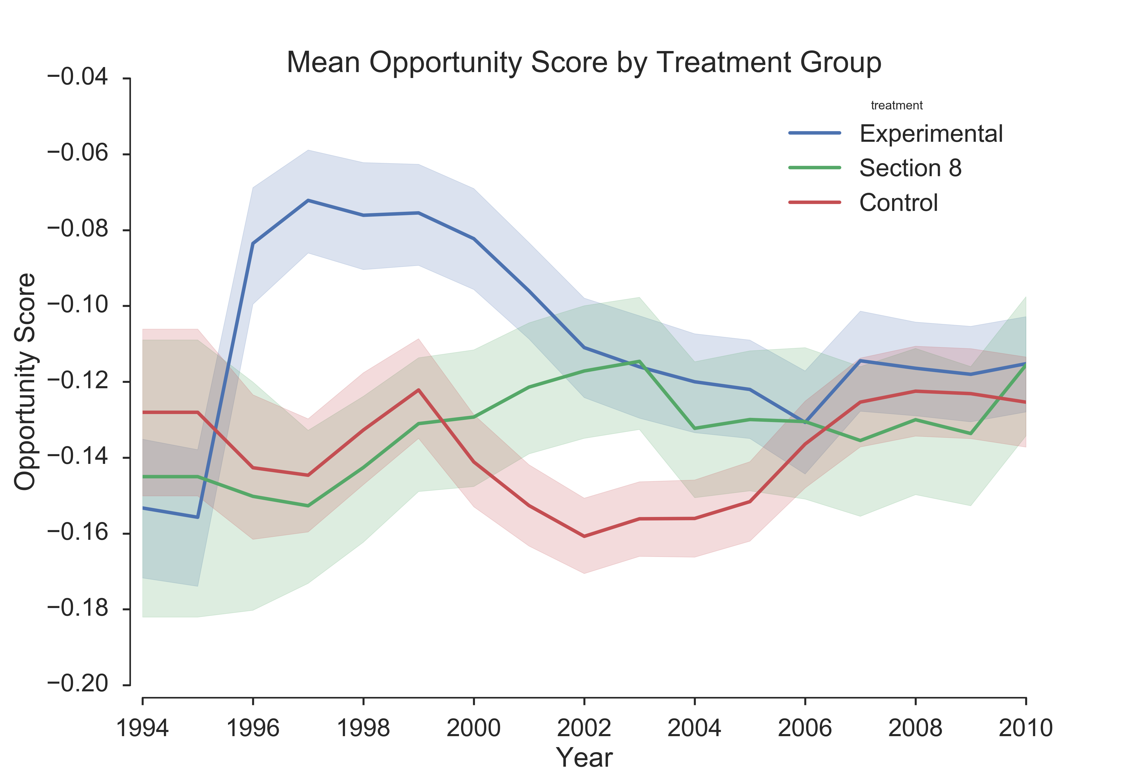
The Federal “Moving to Opportunity for Fair Housing Demonstration” is one of the most important housing experiments in American history, but the findings regarding its policy efficacy were nuanced. This project examined the neighborhood conditions of MTO participants, using a more complex definition of “opportunity,” showing that moves to high opportunity locations were seldom and often short-lived. The households with the greatest gains were often assisted by automobile mobility, reinforcing the critical links between housing assistance, employment accessibility, and regionally-focused policy measures.
More