import osimport contextily as ctximport geopandas as gpdimport matplotlib.pyplot as pltimport pandarm as pdnaimport pandas as pdimport tempfileimport urllib.requestfrom geosnap import DataStorefrom geosnap.io import get_census, get_lodes, get_network_from_gdffrom libpysal.graph import Graphfrom mapclassify import classifyfrom pointpats import weighted_mean_centerfrom shapely.geometry import Pointfrom tqdm.auto import tqdmfrom urllib.error import URLErrordatasets = DataStore()%load_ext jupyter_black
OMP: Info #276: omp_set_nested routine deprecated, please use omp_set_max_active_levels instead.
How big (in land area) is the population center of each region?
One way to understand population concentration and urban growth is to measure the share of land required to capture 10% (or some other proportion) of the metropolitan region’s population. That task is less straightforward than it sounds because we have to first know where the city center is, then devise a method for understanding how much land is required to meet some given population threshold.
In this case, we will assume the location of the metropolitan region is exogenous and represented by (the geometric center of) the largest principal city in each metropolitan region. To get a sense where that is, we first need data from the Census Bureau’s set of “census designated places” files, which include both incorporated cities and city equivalents. We can read these directly from the Census FTP site. As with most Census data, the places as they are known are stored individually by state. Places (cities, from here onward) often have awkward shapes, and there are a lot of them. Here is what they look like in Maryland
Code
zfilename ="tl_2019_24_place.zip"# download the zip file onto the local diskurllib.request.urlretrieve(f"ftp://ftp2.census.gov/geo/tiger/TIGER2019/PLACE/{zfilename}")df = gpd.read_file(f"./{zfilename}")df.explore()
Make this Notebook Trusted to load map: File -> Trust Notebook
Here is a lazy way to read in all the states. I know FIPS codes start at 01 and end at 72, but they are not a strictly increasing series. If we try to read a file that does not exist, geopandas returns an HTTPError, so (barring any other exceptions) we could just try to read all the states in a series, allowing an exception for the ones we know will fail.
This no longer works because the Census Bureau seems to have changed their webserver to require a useragent. We could spoof a browser agent, but (a) that’s technically against their terms of service, and (b) you need to cleverly re-spoof using different useragents so it’s better to use a different strategy. Instead, we will use the Census’s FTP interface and save each file to a temporary directory (which is automatically cleaned up using a context manager). When the file doesn’t exist, the urllib package will throw a URLError.
Code
states = [str(i).rjust(2, "0") for i inrange(1, 72)]places = []for state in states: zfilename =f"tl_2019_{state}_place.zip"try:with tempfile.TemporaryDirectory() as tmpdirname: urllib.request.urlretrieve(f"ftp://ftp2.census.gov/geo/tiger/TIGER2019/PLACE/{zfilename}",f"{tmpdirname}/{zfilename}", ) df = gpd.read_file(f"{tmpdirname}/{zfilename}") places.append(df)except URLError:print(f"{state} does not exist")df = gpd.GeoDataFrame(pd.concat(places))
03 does not exist
07 does not exist
14 does not exist
43 does not exist
52 does not exist
57 does not exist
58 does not exist
59 does not exist
61 does not exist
62 does not exist
63 does not exist
64 does not exist
65 does not exist
67 does not exist
68 does not exist
70 does not exist
71 does not exist
14.1 Locating the Center of the Region
Here, we take the center of the region as exogenous: it is defined as the geometric center of the principal city in each metropolitan region. Thus, we first filter on ‘principal cities’, which have a convenient flag in the Census Place data
Code
df = df[df.PCICBSA =="Y"]# places where the secondary city is larger than the 'true' principal citydf = df[~df.NAMELSAD.isin(["Hammonton town", "Port Arthur city"])]df = df.to_crs(4326)df.info()
For this analysis, we are interested in large metropolitan areas, not micropolitan regions, so we next take the outline of CBSAs in the U.S. and select the principal cities that intersect each.
Code
metros = datasets.msas()metros = metros[metros["type"].str.startswith("Metro")]cities = df[df.representative_point().intersects(metros.union_all())]cities = cities.reset_index()
But that still leaves one lingering issue because there is still not a 1:1 relationship between cities and metros… Some regions have more than one principal city! What about famously twin cities like Minneapolis/St-Paul or Dallas/Fort Worth? To handle those cases, we will take a multi-step approach. First, we will assume any time there are multiple ‘principal cities’ inside a single metropolitan region, they can be collapsed into a single entity if they share a border. To handle cases when there are multiple cities who do not touch each other, we will take the largest polygon in total land area (after dissolving shared borders). First we need to know which cities share a border, which is easy using a libpysal Graph.
Code
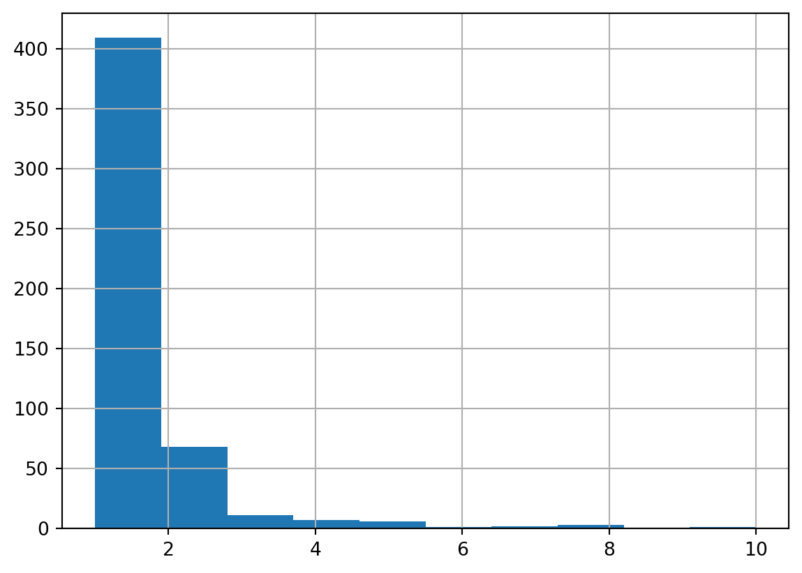
w = Graph.build_contiguity(cities, rook=False)cities["labels"] = w.component_labelscities.labels.value_counts().hist(figsize=(5,2))plt.show()
Histogram, Count of Principal Cities in each Metropolitan Region
The histogram of component labels shows us most central cities are singletons (i.e. monocentric, according to the Census), with a long right tail. There are some places with up to 10 contiguous principal cities in a single metropolitan region
Make this Notebook Trusted to load map: File -> Trust Notebook
What a surprise… it’s [the famously sprawling] Los Angeles metro. Obviously, this is is a drawback of applying this method blindly or at scale. Some regions (L.A. included) are distinctly polycentric, and the ‘core’ in these places is not represented well by a single point in the middle of a single city.
Code
cities = cities.dissolve(by="labels")
Now, if there are any co-principal cities that share a border, they will be treated as a single place. For convenience, we will keep both point and polygon representations of the principal cities.
/var/folders/j8/5bgcw6hs7cqcbbz48d6bsftw0000gp/T/ipykernel_5398/1564437909.py:2: UserWarning: Geometry is in a geographic CRS. Results from 'centroid' are likely incorrect. Use 'GeoSeries.to_crs()' to re-project geometries to a projected CRS before this operation.
cities["point"] = cities.centroid
/var/folders/j8/5bgcw6hs7cqcbbz48d6bsftw0000gp/T/ipykernel_5398/1564437909.py:4: UserWarning: CRS mismatch between the CRS of left geometries and the CRS of right geometries.
Use `to_crs()` to reproject one of the input geometries to match the CRS of the other.
Left CRS: EPSG:4326
Right CRS: EPSG:4269
centers = gpd.sjoin(
We need an appropriate coordinate system to compute area for all polygons in the US. We will use the Albers conic projection, which works nicely for the lower 48 (but probably won’t work too well in Alaska or Hawaii)
Code
centers = centers.to_crs(5070)centers["area"] = centers.area # persist the area as a columncenters = centers.to_crs(4326)
Now for each metropolitan area, we take only the city with the largest land area
centers = centers[idx]# this is a one-liner that does the same thingcenters = centers.iloc[centers.reset_index().groupby(["geoid"])["area"].idxmax()]# the centroid of each poly has moved after mergingcenters["point"] = centers.centroid
/var/folders/j8/5bgcw6hs7cqcbbz48d6bsftw0000gp/T/ipykernel_5398/4177055.py:7: UserWarning: Geometry is in a geographic CRS. Results from 'centroid' are likely incorrect. Use 'GeoSeries.to_crs()' to re-project geometries to a projected CRS before this operation.
centers["point"] = centers.centroid
Here I will define a little function called concentrics that takes an origin point and incrementally grows a polygon outwards until the polygon captures a pre-defined share of the regional “population”. We will make the “population” an input variable here, so that later we can compare concentration pattens for different target groups (e.g. jobs versus households).
Code
def concentrics(df, center, threshold=0.1, step=500, popvar="n_total_pop"): total_pop = df[popvar].sum() total =0 distance =500 df = df.to_crs(df.estimate_utm_crs()) center = center.to_crs(df.crs)while total < threshold * total_pop: ring = center.buffer(distance) total = df[df.centroid.intersects(ring.union_all())][popvar].sum() distance += stepreturn distance, ring.to_crs(4326)
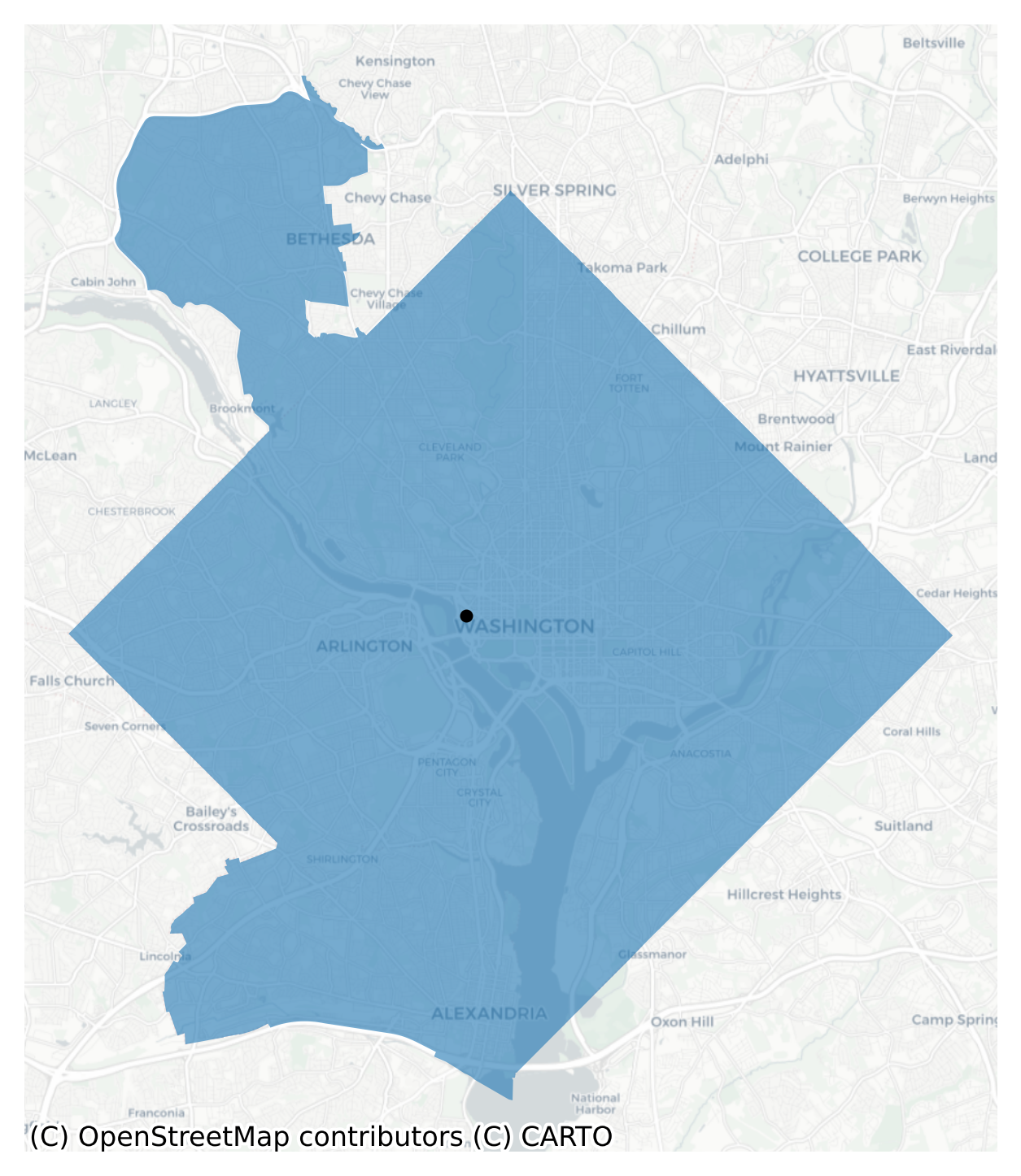
14.1.1 An Example in Washington D.C.
This is the center of the D.C. region, and we can see it has been pulled westward slightly because the District has been merged with Bethesda and Arlington.
/var/folders/j8/5bgcw6hs7cqcbbz48d6bsftw0000gp/T/ipykernel_5398/3053359086.py:1: UserWarning: Geometry is in a geographic CRS. Results from 'centroid' are likely incorrect. Use 'GeoSeries.to_crs()' to re-project geometries to a projected CRS before this operation.
subset = dc[dc.centroid.intersects(ring.union_all())]
In DC, it takes 8km traveling outward from the center of the city to reach 12% of the region’s population
14.1.2 All Metropolitan Regions in the U.S.
To look at the whole country, we just need to wrap the concentrics function in to a for loop and let it run in each region. Unlike above, here we will use the population-weighted centroid of the census blockgroups that fall inside the principal city (rather than the simple geometric center). Also, in this larger example we will search out for the 20% population ring. On my machine it takes roughly 1.5 minutes to let this run.
Code
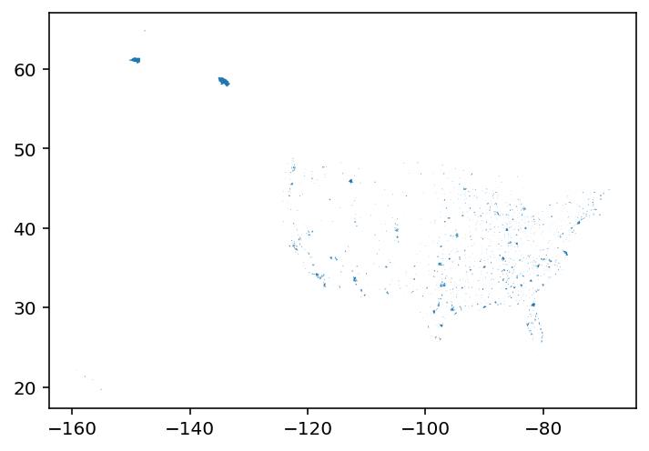
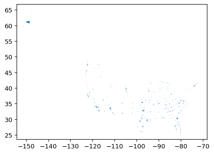
bufs = []for i, row in tqdm( centers.iterrows(), total=centers.shape[0],): record = {"name": row["name"]} geom = gpd.GeoSeries(row.poly) df = get_census(datasets, msa_fips=row.geoid, years=[2010]) geom.crs =4326 df.crs =4326 df = df.to_crs(df.estimate_utm_crs()) geom = geom.to_crs(df.crs)# grow from the population-weighted centroid of the tracts in each city temp_pop = df[df.centroid.intersects(geom.union_all())] center = gpd.GeoSeries( [ Point( weighted_mean_center( temp_pop.centroid.get_coordinates().values, temp_pop.n_total_pop.fillna(0).values, ) ) ], crs=df.crs, ) dist, ring = concentrics(df=df, threshold=0.2, center=center) record["dist"] = dist record["geometry"] = ring.geometry record["geoid"] = row.geoid bufs.append(gpd.GeoDataFrame(record))city_buffers = pd.concat(bufs, axis=0)city_buffers = city_buffers.set_index("geoid")city_buffers[["name", "dist"]].head()m = city_buffers.explore(color="red")metros.simplify(0.0001).explore( m=m, style_kwds={"weight": 1.5, "fill": False}, marker_kwds={"fill": False})
Make this Notebook Trusted to load map: File -> Trust Notebook
The resulting map shows the minimum travel distance necessary to hit 20% of the region’s population (according to the ACS). This is a bit like a nuanced take on a population density gradient; since we’re holding the 20% share constant across regions, then asking “how far do we need to buffer?”, we’re implicitly looking at density. Metropolitan regions with larger radii are places with lower density gradients. At some scales, this can also be viewed as a measure of urban sprawl, for example by creating a ratio of area covered in the red buffer zone to the total urbanized area in the region. In that index, values closer to one indicate prevalence of sprawl.
Note
One interesting thing about the map is how well most circles fit inside each metropolitan region’s “beltway” highways, especially in the Midwest. Take a look, for example, at Indianapolis, IN, Columbus, OH, or Decatur, IL, all of which appear to have a circle inscribed perfectly inside their ring highway. That would seem to provide some small qualitative evidence that our technique has some face validity and is doing a decent job of capturing the central population region of each place. The share of land between the central ring and the ring highway could also be an interesting metric in its own right.
The map also suggests some evidence of monocentricity in most places (at least at a certain spatial scale), since the simple assumption of placing the “center” in the middle of the principal city seems to hit the center of the beltway.
# top five smallestcity_buffers.sort_values("dist", ascending=True)[["name", "dist"]].head()
name
dist
828
State College, PA
1500
116
Corvallis, OR
2500
195
Dubuque, IA
2500
490
Lebanon, PA
2500
564
Midland, MI
2500
Code
# top five largestcity_buffers.sort_values("dist", ascending=False)[["name", "dist"]].head()
name
dist
625
North Port-Sarasota-Bradenton, FL
25000
606
Naples-Marco Island, FL
23500
561
Miami-Fort Lauderdale-Pompano Beach, FL
21000
167
Dallas-Fort Worth-Arlington, TX
19500
1
Atlanta-Sandy Springs-Alpharetta, GA
18500
Code
# top five relative densitycity_buffers.sort_values("ratio")[["name", "ratio"]].head()
name
ratio
309
Anchorage, AK
7.094283e-08
126
Flagstaff, AZ
9.310453e-08
473
Lake Havasu City-Kingman, AZ
1.434168e-07
232
Fairbanks, AK
1.817576e-07
54
Boise City, ID
2.120971e-07
Code
# top five relative sprawlcity_buffers.sort_values("ratio", ascending=False)[["name", "ratio"]].head()
name
ratio
866
Trenton-Princeton, NJ
0.000018
632
Ocean City, NJ
0.000007
159
Gettysburg, PA
0.000007
260
Carson City, NV
0.000006
152
Gainesville, GA
0.000005
That also means the technique just explored here is little more than a simple density search. The origins of the search, the values that define density, and the impedance that defines travel distance are all arbitrary. For example we could also search for employment density gradients (instead of population), starting from the middle of employment centers or weighted centroids (instead of administrative areas) and traverse the travel network (instead of Euclidean distance). From a computational perspective, you could also move incrementally through a KDTree of nearest neighbors instead of repeatedly buffering the origins.
14.2 Comparing Density Gradients
One useful application for this method is comparing change over time. For example if a new land-use policy (such as an urban growth boundary or a priority funding area) is adopted, this method might be useful for understanding the impact of such a policy. In general, if such a policy is effective, we would expect urban growth to be contained leading the region to densify. We can ask if that happened in the D.C. region by comparing the 2010 and 2020 10% population rings.
14.2.1 Change Over Time
This time we will use LODES data, which only covers employees, not the entire population, but that is ok for this example. LODES data are nice because they are extremely high resolution in both space (census blocks) in time (annual releases)
Make this Notebook Trusted to load map: File -> Trust Notebook
Code
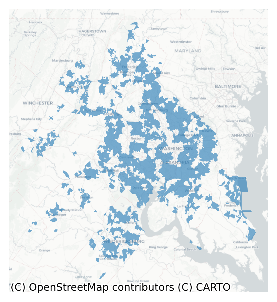
m = ring20.plot(color="red", alpha=0.5)wacring.plot(color="blue", ax=m, alpha=0.5)m.axis('off')ctx.add_basemap(ax=m, source=ctx.providers.CartoDB.Positron, crs=ring20.crs)
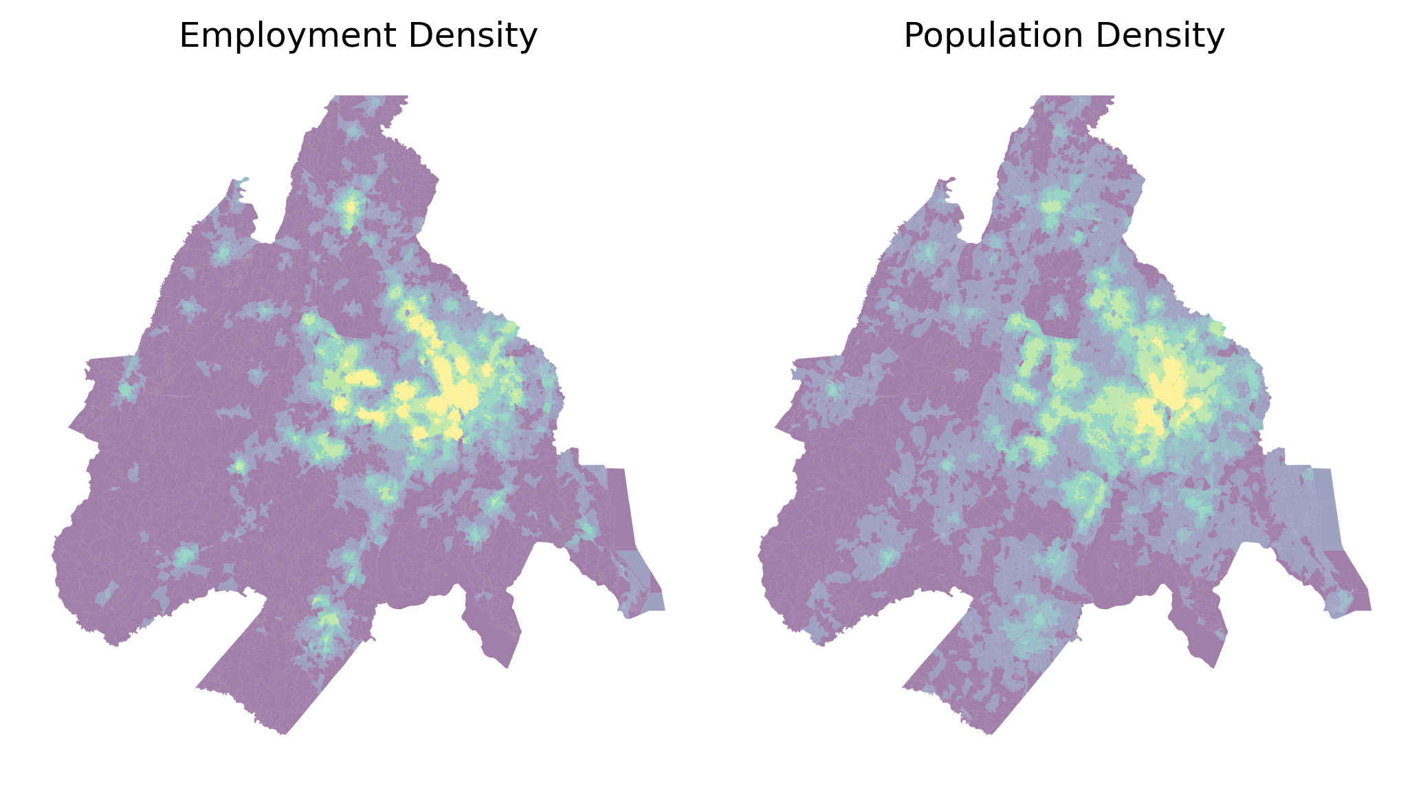
Twenty Percent Population and Employment Rings in the D.C. Region
This is essentially a top-down view of Figure 13.1 because we know that density is a proxy for land prices.
“Density increases at sites with greater location rent because as land rents rise, developers substitute away from land and use more structure capital. More valuable land is used more intesely. As we consider residential density at different sites within the city, density normall tends to be higher at more valuable locations”
In this way, we can use density to understand relative value among different groups of land consumers1. Any place where job density exceeds residential density is a place more valuable to businesses than people, and any place more dense with people than cows (or corn) is more valuable to people than farms.
The blue ring is the 10% ring for jobs (at their workplace) in the region and the red ring encapsulates 10% of the employees (at their homes). This is the concept of bid-rent. Jobs concentrate more densely than population because commerce gets more value from agglomeration/concentration into a central core. Thus, the density gradient for jobs is much higher
To estimate the density gradient, we will use a slightly more detailed approach based on the street network configuration, beginning with downloading a representation of the network from OpenStreetMap. This takes around 10 minutes on my machine–it’s a lot of data! You can skip this step by downloading an old version of the DC network, e.g with
import quilt3 as q3b = q3.Bucket("s3://spatial-ucr")b.fetch("osm/metro_networks_8k/47900.h5", "./47900.h5")
then reading in the h5 file using pandana
Code
# this will take awhiledcnet = get_network_from_gdf(dc20)
Generating contraction hierarchies with 16 threads.
Setting CH node vector of size 965860
Setting CH edge vector of size 2606634
Range graph removed 2682048 edges of 5213268
. 10% . 20% . 30% . 40% . 50% . 60% . 70% . 80% . 90% . 100%
Following, we attach the Census Block data to their nearest intersections in the street network and initialize the values for jobs and people at these locations
/var/folders/j8/5bgcw6hs7cqcbbz48d6bsftw0000gp/T/ipykernel_5398/1957138492.py:1: UserWarning: Geometry is in a geographic CRS. Results from 'centroid' are likely incorrect. Use 'GeoSeries.to_crs()' to re-project geometries to a projected CRS before this operation.
dc20["node_ids"] = dcnet.get_node_ids(dc20.centroid.x, dc20.centroid.y)
Removed 17389 rows because they contain missing values
Removed 38579 rows because they contain missing values
Then we perform two aggregation queries (once each for jobs and people) to generate an accessibility surface, as in Chapter 11, which approximate a continuous density function for each population, and reattach the variables onto the dataframe.
Make this Notebook Trusted to load map: File -> Trust Notebook
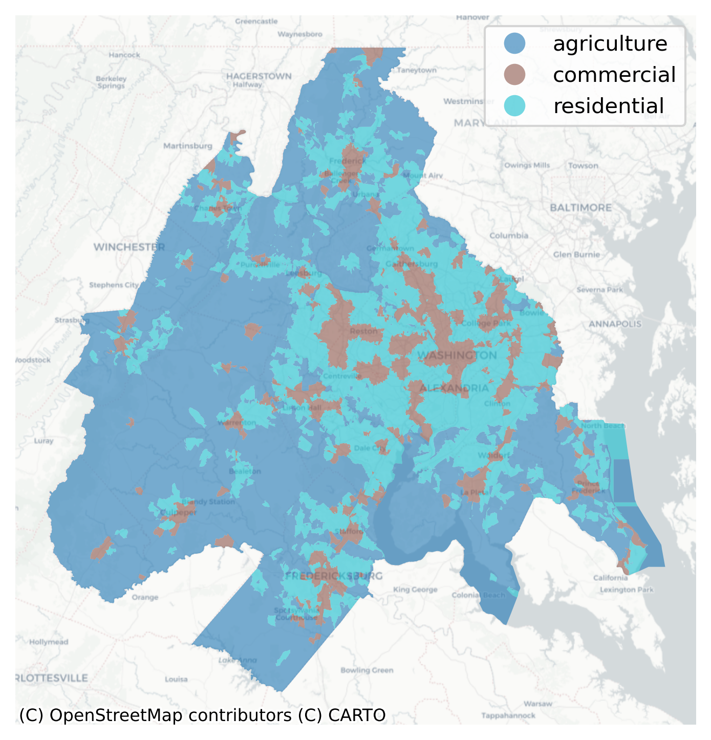
According to the bid-rent theory, these polygons cover the ‘market area’ portion of the metro region. The blue areas are job centers that import workers during the daytime. This looks messy and even a bit diffuse at first. Looking closer, it’s easy to notice that the polygons cling to transport infrastructure (highways). The “CBD” stretches from Alexandria in the south, up Wisconsin Ave (MD-355) into Bethesda, and through I-720 into Gaithersburg. The influence of the Capitol Beltway (I495) and the VA highways (I66 and VA28, in particular) is also obvious.
Part of the reason for the odd shape is DC’s polycentric economy and another is because of the heterogeneity in the size and shape of Census Blocks. If we used a more regular input shapes (like a hexgrid) the resulting pattern would be more uniform. By contrast, this is the residential zone, where residential density exceeds employment density. Let’s also set an arbitrary floor of roughly 0.5 person/sqkm to represent the lower bound (under which we expect agriculture or another super low-intensity land-use to be more prevalent).
Residential Areas where Population Density Exceeds Job Density
The blue areas above are the bedroom communities that export workers into job centers. In the concentric ring examples, we implicitly adopt the monocentric city model. That is, we assume there is a single “center” of each metropolitan region represented by the middle of its principal city. Conceptually, this point is used as an approximation to the Central Business District. In Chapter 15, we allow the business district to be endogenous, and explore techniques for locating regionally-important employment centers (which could then be used as the growth centers here).
And this is the simple, top-down version of Figure 13.1 that does not assume the monocentric model. Instead of the classic ‘commercial, residential, agriculture’ typology, we might have instead called these three land-uses ‘urban, suburban, and exurban’. In this example there will be some boundary effects, especially on the northeastern edge that abuts the Baltimore region because we’ve ignored access to jobs in the northward direction (which is not critical here, but something to beware). Another useful growth management metric might be the ratio of areas between these different land uses over time.